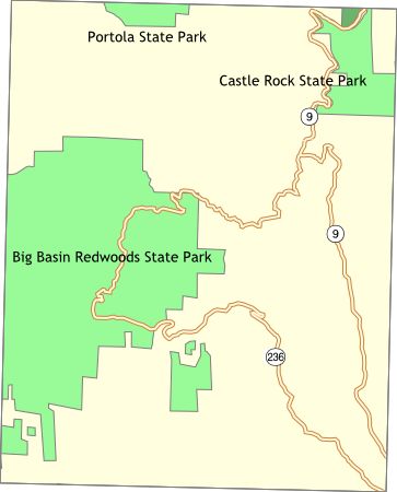
Bay Area Backcountry: Big Basin
|
|
| Up |
|
OverviewBig Basin has 19,000 acres of first-growth redwood forests. Nice temperatures all year round. Very wet early in the year. There is no potable water at any of the trail-camps. The streams are polluted by nearby civilization, so boil, filter, or treat all water before consumption. The Skyline-to-the-Sea Trail runs through Big Basin - you can follow it uphill to Castle Rock State Park or downhill to the Rancho del Oso nature center near Highway 1. Reservations are accepted for campsites, and a permit must be obtained from the Ranger's Station before camping at the trail sites. |
Activities
Backpacking
Getting ThereFrom highway 17, take Mt. Hermon Road west from Scott's Valley to Felton. Then follow highway 9 to highway 236. Highway 236 leads into the park. USGS 7.5' Topo Maps
Davenport
Further Information
Big Basin Redwoods State Park
Links
Mapquest.com Map
|
OverviewCastle Rock straddles the ridge line of the Santa Cruz Mountains. From some spots one can see the ocean, and from others Santa Clara valley. There are 23 miles of trails through many distinct environments. This is not a major camping spot, although there are a few rustic sites. Primarily Castle Rock is a starting point for the Skyline-to-the-Sea Trail . The park is also a major site for rock climbers. The rustic sites have potable water. No reservations are accepted, nor are they needed. There have been thefts from cars and parking in the lot might help (if there are rangers on duty). The lot is open from sunrise to sunset. |
Activities
Hiking
Getting ThereThe main parking lot is two or three miles south of Highway 9 on Skyline Boulevard. USGS 7.5' Topo Maps
Big Basin
Further Information
Castle Rock State Park
Links |
OverviewThe Midpeninsula Regional Open Space District maintains a large amount of open land from Santa Clara County to San Mateo County. Most of their preserves are open for hiking between sunrise and sunset. Some of the preserves have equestrian access. One offers campsites for backpacking. Their web site is well organized and simply gorgeous. |
Activities
Hiking
Getting ThereUSGS 7.5' Topo Maps
Loma Prieta
Further InformationLinks |
OverviewPortola State Park occupies a large basin - you will be hiking among ferns and first and second growth redwoods. There are trails connecting Portola to Castle Rock, Sanborn Canyon, and Big Basin. Portola is often empty - you can get the whole canyon to yourself on weekdays. Main campground has restrooms, hot showers, and mosquitoes - each campsite has a table and stove. There are three trail camps: Slate Creek 2.5 miles from the park headquarters, Tarwater is also 2.5 miles, and another camp is 0.6 miles. |
Activities
Hiking
Getting ThereFrom Highway 35, take Alpine Road southward to Portola Park Road. Travel to end of Portola Park Road. USGS 7.5' Topo MapsFurther Information
Portola State Park
Links |