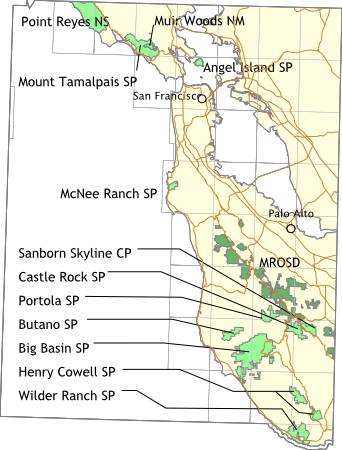
Bay Area Backcountry: San Francicso
|
|
OverviewAngel Island is out in the middle of San Francisco Bay . Camping there is well worth it - you stand a strong chance of sharing the island with only a dozen or so other people, none of them within eyeshot. For day travellers, there are nice roads for cycling, bike and kayak rentals, a coffee shop, and a mini-mountain to climb. There are nine environmental sites. Potable water is available at each site. The last ferry off the island leaves at 4:30pm - after that you may have the place to yourself. Reserve a campsite well in advance. A weather note: think of Angel Island as a cold version of San Francisco. Bring warm clothing - lots of warm clothing if you will camp. |
Activities
Camping
Getting ThereThe only way onto the island is by ferry - board the ferry at Fisherman's Wharf, Tiburon, or Vallejo. Tiburon is the cheapest choice, expect around $10 for Fisherman's Wharf or Vallejo, and $7 for Tiburon. The ferry ticket includes admission to the park. USGS 7.5' Topo MapsFurther InformationLinks |
OverviewBig Basin has 19,000 acres of first-growth redwood forests. Nice temperatures all year round. Very wet early in the year. There is no potable water at any of the trail-camps. The streams are polluted by nearby civilization, so boil, filter, or treat all water before consumption. The Skyline-to-the-Sea Trail runs through Big Basin - you can follow it uphill to Castle Rock State Park or downhill to the Rancho del Oso nature center near Highway 1. Reservations are accepted for campsites, and a permit must be obtained from the Ranger's Station before camping at the trail sites. |
Activities
Backpacking
Getting ThereFrom highway 17, take Mt. Hermon Road west from Scott's Valley to Felton. Then follow highway 9 to highway 236. Highway 236 leads into the park. USGS 7.5' Topo Maps
Davenport
Further Information
Big Basin Redwoods State Park
Links
Mapquest.com Map
|
OverviewButano occupies a large canyon climbing inland from the coast. The canyon is heavily forested with redwoods, with occasional meadows and fern grottos. An especially nice trail runs around the rim of the canyon. You can hike the fire roads all the way to Big Basin State Park. Bicycle friendly - there are over 10 miles of fire roads for riding. Bikes are not permitted on the trails. Campground have restrooms, each campsite has a table and stove. Some of the sites are walk-in, although not a long walk. Water and toilets are available. There is also a trail camp - no potable water, but some unreliable streams are nearby. |
Activities
Backpacking
Getting ThereFrom Highway 1, take Pescadero Road past the town of Pescadero to Cloverdale Road, then turn southward and drive about five miles until you find the park. USGS 7.5' Topo MapsFurther Information
Butano State Park
Links |
OverviewCastle Rock straddles the ridge line of the Santa Cruz Mountains. From some spots one can see the ocean, and from others Santa Clara valley. There are 23 miles of trails through many distinct environments. This is not a major camping spot, although there are a few rustic sites. Primarily Castle Rock is a starting point for the Skyline-to-the-Sea Trail . The park is also a major site for rock climbers. The rustic sites have potable water. No reservations are accepted, nor are they needed. There have been thefts from cars and parking in the lot might help (if there are rangers on duty). The lot is open from sunrise to sunset. |
Activities
Backpacking
Getting ThereThe main parking lot is two or three miles south of Highway 9 on Skyline Boulevard. USGS 7.5' Topo Maps
Big Basin
Further Information
Castle Rock State Park
Links |
OverviewHenry Cowell State Park is a lot like Big Basin , but without the rustic camping sites. There is a large campground which can hold even the biggest motor home. A trail connects Henry Cowell and Big Basin. |
Activities
Backpacking
Getting ThereHenry Cowell is on Highway 9 near Felton. USGS 7.5' Topo MapsFurther Information
Henry Cowell State Park
Links |
OverviewNo camping here. The goal here is to go up Montara Mountain, look at the great view, then head back down. Repeat as needed. (The hike is strenuous, but well worth it for the view of, well, fog. Very nice fog. Plan on four or five hours for the round trip.). Bring all the water you need - there is none available. You might want to bring a light jacket too. Open from dawn to dusk. |
Activities
Dogs Allowed
Getting ThereMcNee ranch is on Highway 1, just north of Montara. Park in a small lot just south of the ranch, on the west side of the highway. If you can't park there, park at Montara State Beach just a little distance to the south. USGS 7.5' Topo MapsFurther Information
San Mateo Coast District
Links |
OverviewFrom the top of Mt. Tamalpais you can see the Farallon Islands, the Sierra Nevada, and the Cascades. The park is big by itself, but the trails also extend into the surrounding countryside. There is a walk-in campground, Pantoll, with potable water and restrooms. No reservations accepted. Lee Shansky Memorial Trail Camp, just a few miles south of Pantoll, has environmental sites - no water or toilets. Reservations are recommended. Alice Eastwood Group Campground has all of the normal features and can handle 100 people. Reservations required. There are also some cabins and a few environmental campsites in Steep Ravine, overlooking the Pacific Ocean. One of the cabins is handicap accessible. Water and toilets are available. Reservations required. You can walk to the Muir Woods National Monument (the two parks share a border). Trails also extend into the undeveloped areas around the parks. |
Activities
Backpacking
Getting ThereFrom Highway 101 near Mill Valley, take Highway 1 west to the Panoramic Highway then turn northward. The directions for Steep Ravine are completely different - you'll get them when you make a reservation. USGS 7.5' Topo Maps
Point Bonita
Further Information
Mount Tamalpais State Park
Links |
OverviewThe Midpeninsula Regional Open Space District maintains a large amount of open land from Santa Clara County to San Mateo County. Most of their preserves are open for hiking between sunrise and sunset. Some of the preserves have equestrian access. One offers campsites for backpacking. Their web site is well organized and simply gorgeous. |
Activities
Hiking
Getting ThereUSGS 7.5' Topo Maps
Loma Prieta
Further InformationLinks |
OverviewGiant redwoods. No camping. Trails connecting to Mt. Tamalpais State Park . Muir Woods is extremely popular, but some mystical force prevents the crowds from following the Ocean View Trail - take it and you will find solitude. |
ActivitiesHiking Getting ThereFrom Highway 1 near Mill Valley, head westward on Highway. Look for the signs. USGS 7.5' Topo MapsFurther Information
Muir Woods National Monument
Links |
OverviewPt. Reyes has over 60,000 acres of mostly untouched land, extending from the shore over some low hills. There are four campgrounds in the park - camping is allowed only in the campgrounds. Campers are limited to a total of four nights. Check in at the visitor center before departure - trails are often impassable and water at the campgrounds can be tainted. All campgrounds have water, fire grills (you know, a metal box on top of a three foot high pole), toilets, food lockers, and a hitching rail for you horse. Campground reservations are required, and can be made up to three months in advance. Get reservations early - this is a popular place. Just north of Pt. Reyes is a large private campground - Olema Ranch Campground - with water, toilets, and showers. Reservations accepted at (415) 663-8001. $16 and up per night. |
Activities
Backpacking
Getting TherePoint Reyes is located off highway 1, 40 or 50 miles north of the Golden Gate Bridge. The visitor center is near the town of Olema. USGS 7.5' Topo Maps
Bolinas
Further Information
Point Reyes National Seashore
Links
Mapquest.com Map
|
OverviewPortola State Park occupies a large basin - you will be hiking among ferns and first and second growth redwoods. There are trails connecting Portola to Castle Rock, Sanborn Canyon, and Big Basin. Portola is often empty - you can get the whole canyon to yourself on weekdays. Main campground has restrooms, hot showers, and mosquitoes - each campsite has a table and stove. There are three trail camps: Slate Creek 2.5 miles from the park headquarters, Tarwater is also 2.5 miles, and another camp is 0.6 miles. |
Activities
Backpacking
Getting ThereFrom Highway 35, take Alpine Road southward to Portola Park Road. Travel to end of Portola Park Road. USGS 7.5' Topo MapsFurther Information
Portola State Park
Links |
OverviewSanborn Park makes a great start for both the Skyline-to-the-Sea trail and the Bay Area Ridge Trail trail. |
Activities
Camping
Getting ThereDrive up highway 9 from Saratoga to Sanborn Road. If you get to the summit, you went too far. USGS 7.5' Topo MapsFurther InformationLinks |
OverviewWilder Ranch occupies a vaguely south facing hillside near Santa Cruz (it abuts the University of California at Santa Cruz campus). The park was once a ranch and the original buildings are maintained as an interpretive site - they have goats, sheep, chickens, the usual working farm stuff. There is always an assortment of young children at varying levels of excitemenent. Away from the buildings there are a large number of trails, ranging from fireroads to foot paths. All of the trails are open for mountain bikes. Many of the trails are in the open, with no trees around to shelter you from the sun. Wilder Ranch is one of my favorite places for mountain biking. You begin at the lowest elevation, then can make a greuling climb up to the highest area and coast back down to the starting point. There are many singletrack loops which provide variety for the rides. Lots of poison oak along the small shady trails. |
Activities
Hiking
Getting ThereWilder Ranch is located on Highway 1, a few miles west of Santa Cruz (one mile west of Western Drive). Look for the parking lot on the coast side of the highway. USGS 7.5' Topo MapsFurther Information
600 Ocean Street
Links |