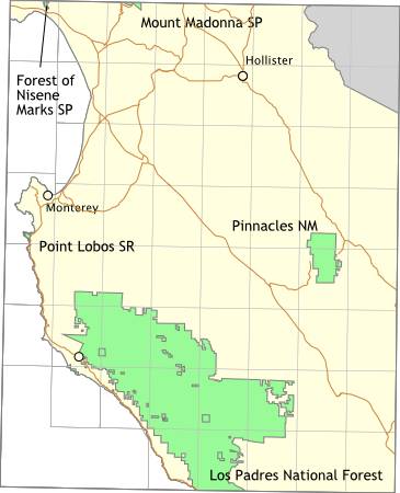
Bay Area Backcountry: Monterey
|
|
|
OverviewTwo million acres - none of it developed. Standard National Forest rules apply - first come first served for camping, no rangers, lots of open land. |
Activities
Backpacking
Getting ThereHead south on Highway 1 to Big Sur. USGS 7.5' Topo Maps
Burnett Peak
Further InformationLinks |
OverviewIf you like steep trails, this is the place. Mt. Madonna Park contains both dense forests and open chaparral. There are several drive-in campgrounds around the park. Sites are available on a first-come first-serve basis. Dogs are allowed around the parking lots and in one campground, but not on the trails. It is possible to walk or bike to Uvas Canyon County Park and the Forest of Nisene Marks State Park from here. No reservations are accepted. |
Activities
Camping
Getting ThereThe entrance is on Highway 152 (the Hecker Pass Highway), between Gilroy and Watsonville, where 152 meets Summit Road. USGS 7.5' Topo MapsFurther InformationLinks |
OverviewThe Forest of Nisene Marks is a marvelous second growth forest - it was logged heavily in the 1800s, but has since recovered completely. The forest today is heavy with redwood and madrone, with an undergrowth of ferns and poison oak. With 9600 acres, there is always plenty of land to explore. The 1989 Loma Prieta earthquake was centered in this park. Follow the Big Slide Trail 'til you find some large cracks in the ground - you won't be at the center, but you will be close. It is possible to walk or bike to Uvas Canyon County Park and Mount Madonna County Park from the Forest of Nisene Marks. There is one trail camp, Westridge Trail Camp, six miles in from the parking lot. Reservations are required. No open fires are allowed - only backpacking stoves can be used. There is a restroom at the trail camp. Open from dawn to dusk for day hikers. Open all the time for campers. Reservations required for the Westridge Trail Camp. They are available from Sunset Beach State Park at (408) 763-7063. |
Activities
Backpacking
Getting ThereFrom Highway 1 in Aptos, take the State Park Road exit to the north. Turn right (eastward) on Soquel Road. Drive under a railroad bridge then look for Aptos Creek Road on the left. The sign is small, so pay attention. There is a parking area right after the turn on Aptos Creek Road. You can park there for free and walk in to the forest, or continue on Aptos Creek Road, pay $3.00, then park back near the trail heads. Bicyclists tend to park at the free lot. USGS 7.5' Topo MapsFurther Information
The Forest of Nisene Marks
Links |
OverviewThe Pinnacles are one half of the core of an extinct volcano. The other half is in Southern California. (Can you guess where a major fault line runs? I knew you could). The core intruded into softer rock, which has since largely eroded leaving the core exposed to view. Springtime is the best time to visit - the temperature is still nice and wildflowers are in bloom. There is a private campground (408 389-4462) just outside of the eastern entrance. The eastern entrance provides convenient access to a nice cave, while the western entrance is best for exploring the pinnacles themselves. There are two caves, not much as caves go but this part of California is largely cave-free, so you have to take what you can get. One cave is very short - perhaps one hundred feet, and the other is about a quarter of a mile long. Neither ever get completely dark, but flashlights are still required. Watch for frogs and bats in the cave. |
Activities
Bikes Prohibited
Getting ThereFor the west entrance use highway 146 from Soledad, on highway 101. For the east entrance, use highway 146 from highway 25, about 15 miles south of Paicines, or 20 miles south of Hollister. USGS 7.5' Topo Maps
North Chalone Peak
Further Information
Superintendent
Links |
OverviewNo camping here, but lots of hiking trails. Seeing an otter is guaranteed. Gray whales can be seen during their southward migration from January to March. |
Activities
Diving
Getting TherePoint Lobos is on Highway 1, about five miles south of Monterey. USGS 7.5' Topo MapsFurther Information
Point Lobos State Reserve
Links |