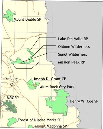
Bay Area Backcountry: San Jose
|
|
Overview720 or so acres, following Penitencia Creek from the Mount Hamilton Range to the valley floor. Not a place for camping. Parking is limited - the best way in is by bike or on foot. |
Activities
Bicycling
Getting ThereFollow Mt. Hamilton Road eastward (head for the observatory) out of San Jose - it passes through the park. USGS 7.5' Topo Maps
Isabel Valley
Further InformationLinks |
OverviewThe road to Henry Coe is long, twisty, and narrow, but the reward is reaching 80,000 acres of barely touched wilderness. On weekdays, it is possible to have the park all to yourself, while on weekends the parking lot is crowded with the cars of mountain bikers (excellent trails for biking, by the way). Even when the lot is full, the population density in the park is still low. Backpacking requires checking in at the ranger station. Open fires are usually prohibited. All of the camping areas are near water (streams, lakes, or springs) - filtering the water is advised - but many of the streams run dry during summer. Very steep in spots. No bridges across the creeks - they can be difficult to ford during springtime, especially while wearing a pack. |
Activities
Backpacking
Getting ThereFrom Highway 101, follow East Dunne Ave. eastward out of Morgan Hill. Keep going. Go some more. You're not there yet. It's just around that next corner... USGS 7.5' Topo Maps
Pacheco Peak
Further Information
Henry W. Coe State Park
Links
Mapquest.com Map
|
Overview9000 acres of bone dry wilderness, mostly vertical and so scarcely used that you can go off trail without adverse impact. Bicycle friendly. Helmets are required. There is a small campground with water, toilets, and hot showers. No reservations. The campground is open full time from April through October, and sporadically in March and November. |
Activities
Bicycling
Getting ThereFollow Mt. Hamilton Road eastward (head for the observatory) out of San Jose - it passes through the park. USGS 7.5' Topo MapsFurther InformationLinks |
OverviewThis used to be the Del Valle State Recreation Area. The primary attraction is Del Valle Reservoir - a popular place for boating and fishing. More important is the access to the Ohlone Wilderness Trail. Follow the trail for 20 miles to reach the Sunol Regional Wilderness , or just climb the extremely steep bit to reach Murietta Falls (or in summer, the Murietta Dry Streambed). There are two campgrounds. Del Valle Park is at the southern end of Del Valle Reservoir and mainly provides access to a boat ramp. Vendanos campground is only accessible by boat or trail, and sits on the eastern side of the reservoir. Water and toilets are available at both campgrounds. Reservations required in advance - call 510 562-2267. |
Activities
Boating
Getting ThereUSGS 7.5' Topo MapsFurther Information
East Bay Regional Park District
Links |
OverviewPart of the East Bay Regional Park District - this is the western end of the Ohlone Trail. |
Activities
Backpacking
Getting ThereUSGS 7.5' Topo MapsFurther Information
East Bay Regional Park District
Links |
OverviewNot a good place for backpacking, but there are many sites for car camping. Often closed during the summer due to high fire danger, and sometimes snowed in during the winter. The road goes right to the top of the mountain. Horses are allowed on trails. There are two horse campgrounds - both have water and are accessible by trailer. |
Activities
Camping
Getting ThereMt. Diablo is due east from Walnut Creek. From highway 680, use the Treat Blvd./Geary Rd. exit and head east on Treat Blvd. Turn right on Oak Grove Road. A few blocks past Ygnacio Valley Road there are signs to the park entrance. (Further thanks to Jonathan Suite for the improved directions). USGS 7.5' Topo MapsFurther Information
Mount Diablo State Park
Links |
OverviewIf you like steep trails, this is the place. Mt. Madonna Park contains both dense forests and open chaparral. There are several drive-in campgrounds around the park. Sites are available on a first-come first-serve basis. Dogs are allowed around the parking lots and in one campground, but not on the trails. It is possible to walk or bike to Uvas Canyon County Park and the Forest of Nisene Marks State Park from here. No reservations are accepted. |
Activities
Camping
Getting ThereThe entrance is on Highway 152 (the Hecker Pass Highway), between Gilroy and Watsonville, where 152 meets Summit Road. USGS 7.5' Topo MapsFurther InformationLinks |
OverviewThe Midpeninsula Regional Open Space District maintains a large amount of open land from Santa Clara County to San Mateo County. Most of their preserves are open for hiking between sunrise and sunset. Some of the preserves have equestrian access. One offers campsites for backpacking. Their web site is well organized and simply gorgeous. |
Activities
Hiking
Getting ThereUSGS 7.5' Topo Maps
Loma Prieta
Further InformationLinks |
OverviewThe Forest of Nisene Marks is a marvelous second growth forest - it was logged heavily in the 1800s, but has since recovered completely. The forest today is heavy with redwood and madrone, with an undergrowth of ferns and poison oak. With 9600 acres, there is always plenty of land to explore. The 1989 Loma Prieta earthquake was centered in this park. Follow the Big Slide Trail 'til you find some large cracks in the ground - you won't be at the center, but you will be close. It is possible to walk or bike to Uvas Canyon County Park and Mount Madonna County Park from the Forest of Nisene Marks. There is one trail camp, Westridge Trail Camp, six miles in from the parking lot. Reservations are required. No open fires are allowed - only backpacking stoves can be used. There is a restroom at the trail camp. Open from dawn to dusk for day hikers. Open all the time for campers. Reservations required for the Westridge Trail Camp. They are available from Sunset Beach State Park at (408) 763-7063. |
Activities
Backpacking
Getting ThereFrom Highway 1 in Aptos, take the State Park Road exit to the north. Turn right (eastward) on Soquel Road. Drive under a railroad bridge then look for Aptos Creek Road on the left. The sign is small, so pay attention. There is a parking area right after the turn on Aptos Creek Road. You can park there for free and walk in to the forest, or continue on Aptos Creek Road, pay $3.00, then park back near the trail heads. Bicyclists tend to park at the free lot. USGS 7.5' Topo MapsFurther Information
The Forest of Nisene Marks
Links |
OverviewThis is wilderness. Water is scarce, and in summer can be non-existent. For a short visit, approach from Del Valle Regional Park then head for Murietta Falls. The trail to the falls is extremely steep - probably rivals Henry W. Coe for steepest trail - but the trip is worthwhile. Backcountry permit required. |
Activities
Backpacking
Getting ThereWalk from Del Valle Park or Sunol Regional Wilderness Area via the Ohlone Wilderness Trail. USGS 7.5' Topo Maps
Mendenhall Springs
Further Information
East Bay Regional Park District
Links |
OverviewThis is wilderness. Follow the Ohlone Wilderness Trail to either Del Valle Regional Park or Mission Peak Regional Park . Within the wilderness, check out Little Yosemite - a small valley which is almost exactly unlike Yosemite. There is a very small campground with water and toilets, plus a trail camp for backcountry camping. Reservations are required in advance. |
Activities
Backpacking
Getting ThereUSGS 7.5' Topo MapsFurther Information
2950 Peralta Oaks Court
Links
Mapquest.com Map
|